Showing posts with label vacation. Show all posts

Sunday, October 11, 2009

Happy Columbus Day

Christopher Columbus

Christopher Columbus - Kenosha Harbor, Kenosha WI

Friday, July 17, 2009

Fireworks: Fourth of July 2009

Flag

The War on Terror must be going well. For the second year in row the Great Lakes Naval Base has resumed it’s annual Fourth of July fireworks display.


Bandstand

Music

tumbler

Entertainment

Crowd

A crowd of thousands.

Fireworks 1

The best fireworks in Lake County

Fireworks 2

Fireworks 3

Fireworks 4


And more pictures Enjoy

Saturday, September 06, 2008

Oshkosh 2008 AirVentrue - II

More photos from AirVentrue 2008

See my previous post


'“Photobucket

The old and the new.


flags

People came from all over the world for the show.


'“Biplane

A bi plane during the preshow warm ups. It looked for a bit like weather would close the show but a few minutes later it was sky blue flying.


'“C-47

The venerable DC-3 aka C-47. I think the smiley face on it’s nose is because it has survived so long. During the National Anthem it dropped the parachutists who carried the American Flag.


'“Newtower

Oskosh’s brand new Air Traffic Control Tower opened just in time for the Air Show.

See my previous post

And more photo’s in a while.

Sunday, August 10, 2008

Oshkosh 2008 AirVenture

Oshkosh 2008

I went to Oshkosh AirVenture was held last month. The show is sponsored by the Experimental Aircraft Association located at Oshkosh Wisconsin and is one of the premier air shows in the world. I had a great time


Oskosh 2008 Rocket Plane

A racing Rocket plane. Rocket Plane’s have two options engine on and engine off. The plane would come in fast and do some maneuvers than turn the engine off and become a glider as it went around for another turn. This is the first for the Racing Rocket League at Oskosh which hopes to make this a NASCAR style sport.


Photobucket

This ultra light plane was doing “touch and goes” before the show.


And of course Acrobatics.

Acrobatics 1

More

Acrobatics 2
Julie Clark


And more.

Acrobatics 3
Debbie Rhin-Harvey


I’ll post some more later or you can see more pictures here.

Monday, May 26, 2008

Going North

Made my occasional visit to our Marquette Michigan office in the Upper Peninsula.


MAP Upper Peninsula

I took a driving break at a good half way point

45 degrees north

At another break I stopped at Florence Wisconsin and checked the weather station.

Florence WI Weather Station

This is part of the National Network of weather stations that collects data on “global warming” as well as more mundane purposes, like the weather report. The network has come under considerable criticism lately because many (over half surveyed so far) have a larger margin of error than the alleged extant of global warming. I didn’t do a formal survey but this looks much better than most. The white boxes at the bottom are old equipment, the weather station is the little box on the antenna near the top of the picture.


I always plan to travel in the good weather

Photobucket

This the land of the Great North Woods.

Photobucket

Photobucket


Photobucket


Took a wrong turn going home and got to visit Norway

Photobucket

Michigan that is. This town in the late Nineteenth and early Twentieth centurys was the last transit point for settlers from the Scandinavia, from here they went to set up homesteads or got jobs in the mines across the Upper Peninsula and Northern Wisconsin.


More pictures

Tuesday, November 27, 2007

San Antonio Downtown: St Joseph Church

The biggest cultural influence in Texas after the Hispanic and the Scots Irish via the US South were the German Immigrants. The geography was mostly named when they arrived, so there are very few places with a German name. However they were an essential part of the many communities.

St Joseph Church San Antonio

This is St Joseph German Church in downtown San Antonio. Construction was started 1n 1866 and finished in 1878. Now it is surrounded on three sides by a department store that was built around it. Like many down town parishes it serves not just the local community but the workers, and visitors to the down town area.

St Joseph San Antonio Altar

It was a German language parish for many years switching to English only as the membership assimilated. The names of the Stations of the Cross, set in the wall, are in German with English subtitles. But these days the notices on the bulletin board are in English and Spanish.


St Joseph Parish (Downtown)

Sunday, November 04, 2007

San Antonio: Mission San Jose y San Miguel de Aguayo

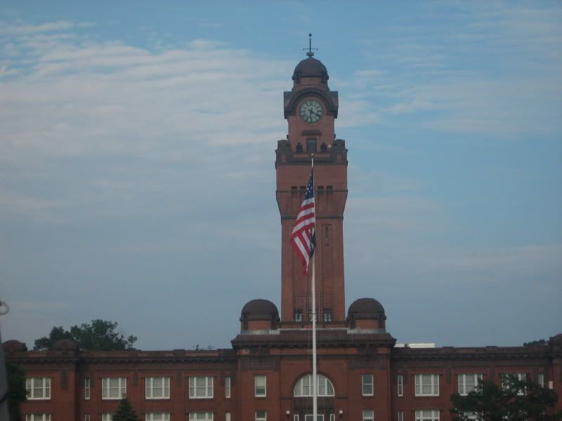
About 1720 Spain established a number of missions near what is now San Antonio. They also built a fort nearby and later settled pioneers from the Canary Islands. The town they founded is now San Antonio. Their parish church renovated many times is now the Cathedral.

The missions, fort, and settlement were established because the French were encroaching on territory that was nominally claimed by Spain and creating a population loyal to Spain would help solidify the claim. It could also function as forward base to defend the more settled parts on New Spain from Apache and Comanche attacks. The plan was to sufficiently integrate the local population into Spanish culture so that they would be loyal to Spain. The Church was willing to participate in order to bring the Gospel to those who had not received it.


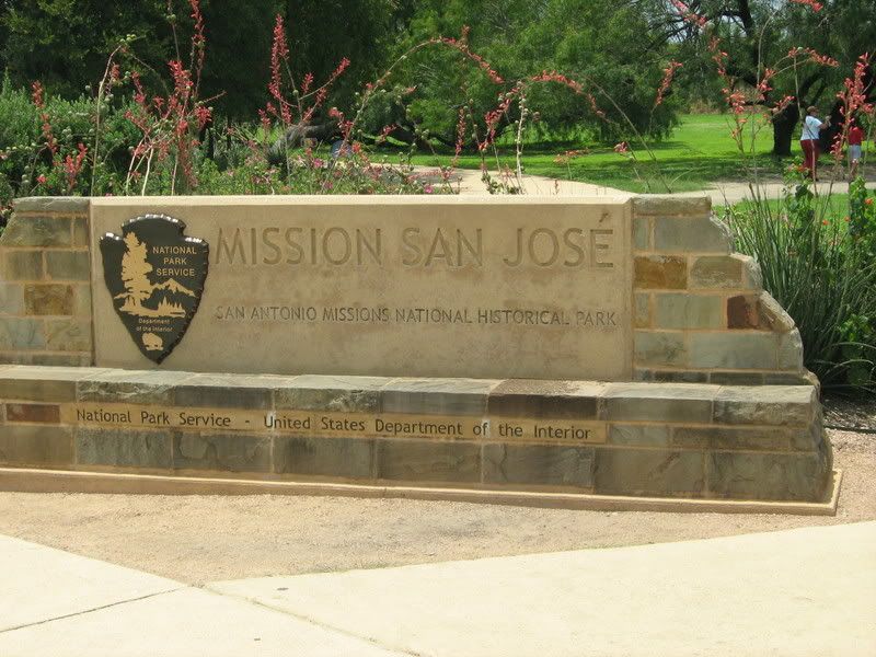
Welcome to the Queen of the Missions

 San Jose Sign

The land and buildings, except for the church buildings, belong to the State of Texas and are administed by the National Park Service The Park Administration building is to the left, with a good museum, a well produced film that is mildly effected by political correctness, and an excellent bookstore that has far more books than my book budget allowed.

The mission was originally established in 1720 by the Franciscan Friars and moved to it’s current and third site in the 1740’s. It was the largest of the missions and most successful. In the 1790’s the mission was secularized though the Franciscans stayed on as parish priests. The land given to the Indians. During the political troubles of the early 18tyh century the mission fell on hard times, the Franciscans were expelled and it operated intermittently as a parish until the 20th Century. In the 1930’s the Mission was restored as a WPA project to it’s late 1700’s plan and became a park. The new San Jose Parish is celebrating the 75th anniversary of it’s reestablishment and is back under the care of the Franciscans.


 San Jose Well

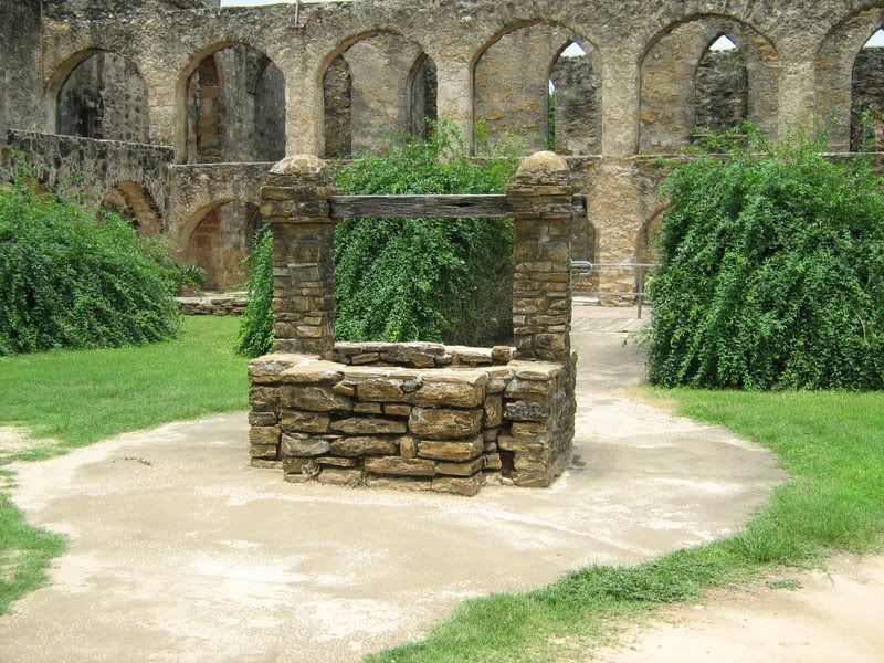
A well and behind it is the convent, the living quarters of the Friars, and the mission office.


 From across mission yard

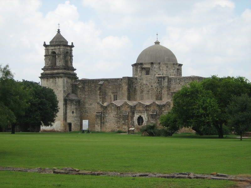
A side view of the church looking north across the Mission Yard.
The mission yard depending on the time of year would have been a center of the different activities associated with a large agricultural operation.


 San Jose Front


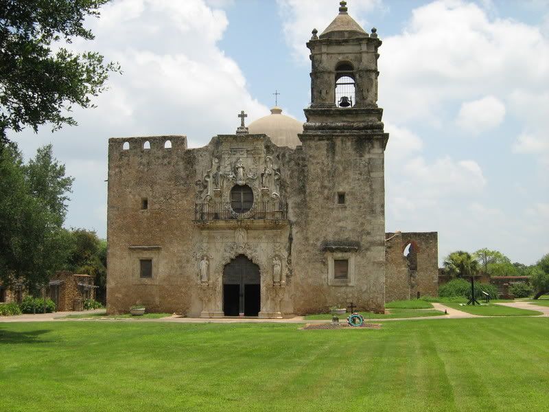
The Front of the Church.
In the 1700's the buildings were painted in bright colors with a combination of Indian, Spanish and Moorish designs.

 San Jose Altar

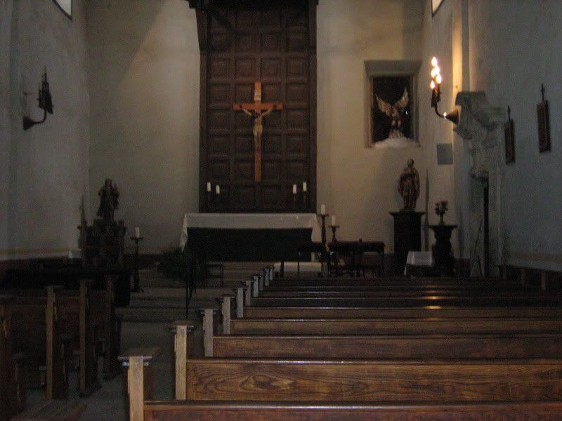
From descriptions the original altar and sanctuary had a much more baroque decoration. One steps into the church and as you subconsciously reach for the Holy Water font you realize this is no longer the National Park Service


Mission San Jose, San Antonio TX copyright Google

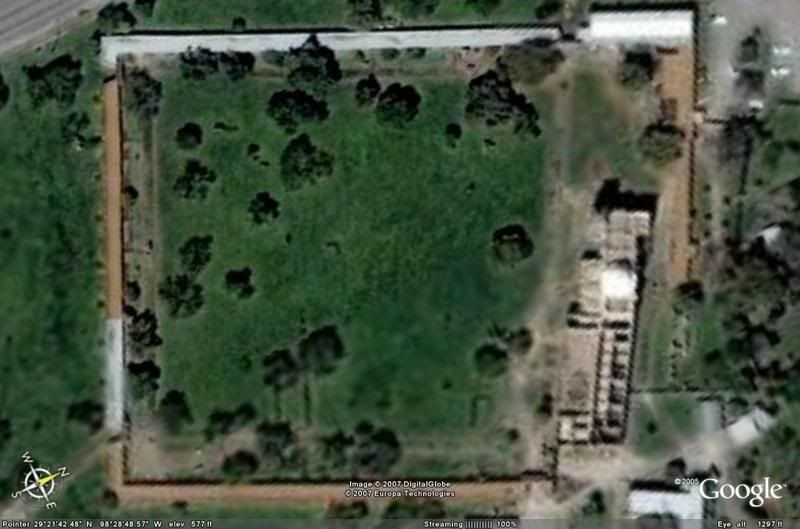
An Earth Google photo.
The Church and Convent are on the right of the yard. The buildings in the bottom right are the modern parish offices. The indians lived in rooms along the side of the walls. The walls were built to keep out Apache and Comanche raiders. Like walls of this type every where, it allowed the most number of people to get a good nights sleep with a minimum guard force as well as provide confidence you would not wake up to hostile warriors in your front door. The Indians formed a militia company with indians as NCO's and officers to defend the mission with two or three Spanish soldiers as trainers, much like National Guard technitions today.


Also see 
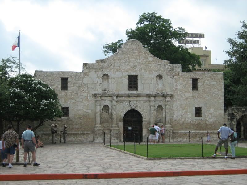
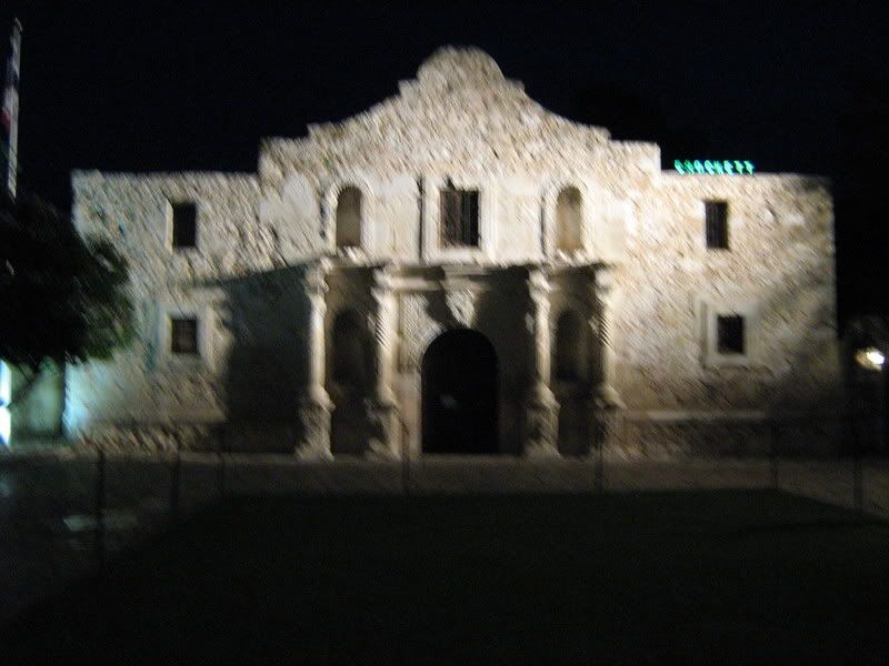
Mission San Antonio de Valero “The Alamo”

Saturday, July 07, 2007

The Alamo

Alamo day

In 1718 Franciscan Missionaries established mission San Antonio Velara which moved to it’s current location in 1724. It was the first of what became five missions, a presidio, and a town settled by pioneers from the Canary Islands. In 1794 the Spanish Government secularized the mission, the Indians were given the land they worked and the church buildings went to the Church and the rest went to the Crown. The Spanish Army took over the common buildings 1n 1801 and they continued in military use for one country or another until 1880’s. The name Alamo most likely comes from the name of the first unit to occupy the site.

Mexico became independent in 1824 with a federal Constitution. And invited American settlers to help populate the land. In 1835 Santa Ana came to power abrogated the Federal Constitution and took away many local rights. In Texas after some attempts to smooth thing over both the American settlers and the local Tejan population rebelled. After much back and forth Santa Ana’s Army came to lay siege to the Alamo.

In 1836 it was the scene of the famous battle where the Texans held out for 13 days against Santa Ana’s much larger Army, going down to the last man, but buying the time for Sam Houston to build up the Texan army and defeat Santa Ana. A more detailed account of the batle is Here.

It is now owned by the State of Texas and entrusted to the Daughters of the Texas Republic as a shrine to those who died here.

An interesting note is that the Mexican solidiers are getting more coverage than previously. Which is good, serving well under a petty tyrant like Santa Ana requires a special valor all to itself.


They did not allow taking pictures inside the Alamo or museum, the Alamo website has a picture

See more pictures here.

Tuesday, July 03, 2007

San Antonio

Work took me to San Antonio last week,
and I stayed the weekend to see the sights.

The Alamo


Mission San Antonio de Valero
AKA
The Alamo


Flags over Texas

The Six National Flags
that have flown over what is now Texas.

The United States

The Republic of Texas

France

Spain

Mexico

The Confederacy
(the national flag, not the battle flag (Stars and Bars.)


Pictures and more this weekend.

Saturday, July 16, 2005

Vacation

I had a great vacation visiting family and visiting historical sites.

If you get to western Virginia I would recommend traveling the Blue Ridge Parkway. It has some majestic views. Be sure you have a full tank. The road goes sideways more often than forward (at one point the GPS said 223 degrees on a road that goes northeast. I came to the gas station at the north end with less than a gallon.


I visited Antietam and Gettysburg battle fields. Looking at the ground sure makes the descriptions clearer. Antietam is a better stop in you can only go one place since it is not mobbed like Gettysburg.


At Antietam more soldiers were killed in single day than in any other battle in North America. Both there, and at Shiloh a few months earlier, more men were killed than in all the previous wars in US history. At this point both sides realized there would be no cheap and easy end to the war. This was General McClellan’s last battle. Like always he had a good plan, but at the end he refused to throw in his last force and allowed the Army of Northern Virginia to survive for three more years. The troops committed by both sides had fought to exhaustion but there were 30,000 uncommitted federal soldiers and the Confederates had no reserves left. A decisive attack would have destroyed or trapped the Confederates. Even if it did not end the war just then Virginia would have been lost to the confederacy along with it’s largest army.


Not having enough time to see every thing at Gettysburg I followed of the second day. Most of the action that day was the result of Sickles poor initial deployments, establishing a line that was to long for his Corp to defend but leaving Little Round Top, the most important terrain feature, undefended. The story of the 20th Maine is often told, how it changed direction under fire to face the Confederates. What does not really come across is how steep and rough that ground is. It looks like a 30% slope. Here also the Regular Army division was destroyed in the effort to save Sickles Corp. The guidebook says they retired in “perfect order.” A nice way to say that when the units next to them were forced off position, they withdrew maintaining formation and firing the whole way back. For the rest of the war they were reduced to a small brigade.

Sunday, June 26, 2005

Going on Vacation

.


Be back in two weeks.

A happy Fourth of July to every one and a

Happy Birthday to the United States.

There is lots of good reading in on side bar. I have some new links.
Copyright 2004-2012 - All rights reserved. All opnions are mine, except comments or quoted material - who else would want them. Site Meter